
Cape Town – Cape Town and much of the Western Cape are bracing for a bout of cold and wet weather this week — a stark reminder of winter’s grip. The conditions are expected to bring heavy winds, high seas, and a risk of localised flooding.
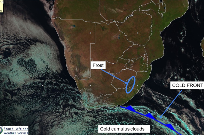
The South African Weather Service has issued a cold front warning from Wednesday to Saturday (18–21 June), with forecasts of strong north-westerly to westerly winds gusting between 60 km/h and 75 km/h along the coast. Swells of 5 to 5.5 metres are expected from Saldanha Bay to Plettenberg Bay.
Daytime temperatures in inland areas are set to plunge below 10 °C, with wet conditions likely to persist intermittently into next week.
⚠️Yellow level 2 warning: Damaging waves
Affected area: Western Cape
Validity period: 18 to 21 June 2025.#saws #weatheroutlook #southafricanweather pic.twitter.com/fP6yFPICo7— SA Weather Service (@SAWeatherServic) June 18, 2025
According to TimesLIVE, the very cold conditions — particularly in interior regions — have prompted the Provincial Disaster Management Centre to issue safety guidance.
The warning comes after a tragic drowning incident at a low-level bridge near Slanghoek the previous week.
The Western Cape Government has echoed the alert, warning of several days of disruptive weather and urging residents to be prepared.
Households are advised to follow a “grab‑and‑go” approach, keeping essential items — such as ID documents, medication, bottled water, phone chargers, and first-aid kits — packed and within reach in case of emergency evacuation.
“These men and women are trained to keep us safe, and they risk their own lives to do this,” the statement read. “We can reduce these risks by giving our full cooperation and embracing a mindset of ‘better safe than sorry.’”
🌤️ Cape Town Weather Forecast
📅 Wednesday, 18 June
🌥️ Turning cloudy later in the day
High: 17°C Low: 10°C
📅 Thursday, 19 June
🌧️ Cloudy most of the day with a few showers
High: 16°C Low: 13°C
📅 Friday, 20 June
🌦️ Sun and clouds with isolated showers
High: 18°C Low: 11°C
📅 Saturday, 21 June
⛅ Cloudy start, then sunny spells
High: 18°C Low: 10°C
These latest weather tensions follow recent localised flooding in Table View, Wynberg, and Parow, where municipal teams have responded to blocked drains and overflowing canals — a reminder that Cape Town’s infrastructure is already under pressure.
During heavy rain, it is important to take note of the following:
- Pay attention to warnings and stay informed. Listen to the radio or check reputable social media such as South African Weather Services or your municipality for updates on where there is a risk of flooding.
- Store a supply of drinking water.
- If you live in a flood-prone area or are camping in a low-lying area, get to higher ground immediately.
- If told to evacuate by authorities, please do so immediately. Lock your home when you leave. If you have time, disconnect utilities and appliances.
- Avoid areas, roads, and passes that are subject to sudden flooding.
- Avoid damaged live electrical infrastructure.
- Do not attempt to walk or drive over a flooded road. Even 15 cm of fast-moving floodwater can knock you off your feet, and a depth of two feet is enough to float a car. Never try to walk, swim or drive through such swift running water.
- Avoid contact with flood water as it can be mixed with sewerage, oil, fuel, or dangerous chemicals. Prevent children from playing in and near flood waters.
Follow African Insider on Facebook, X and Instagram
Picture: X/@SAWeatherServic
For more African news, visit Africaninsider.com
Compiled by Lisabeal Nqamqhele